


Les Damps -Lery

MichelRando7656
User
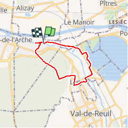

Length
9.6 km

Max alt
89 m

Uphill gradient
112 m
Km-Effort
11.1 km

Min alt
2 m

Downhill gradient
113 m
Boucle
Yes
Creation date :
2019-04-29 10:39:40.372
Updated on :
2019-04-29 10:39:40.426
2h10
Difficulty : Unknown

FREE GPS app for hiking
 SityTrail
IGN / Geographical institutes
SityTrail Plus
The world is yours!
About
Trail Walking of 9.6 km to be discovered at Normandy, Eure, Les Damps. This trail is proposed by MichelRando7656.
Description
Forêts et rivières
Positioning
Country:
France
Region :
Normandy
Department/Province :
Eure
Municipality :
Les Damps
Location:
Unknown
Start:(Dec)
Start:(UTM)
367688 ; 5462784 (31U) N.
Comments